Monday, July 17, 2000

Wright Brothers
Memorial,
Kitty Hawk, NC

Start of First
Airplane Flight
End of First,
Second and Third
Airplane Flights

Cape Hattaras
Lighthouse

Climbing the
Lighthouse
The View
from the Top
Ocracoke to
Cedar Island
Ferry
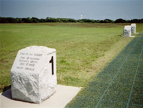
Before leaving Kitty Hawk, I wanted to attend the first presentation of the day at the Wright Brothers National Memorial. It didn't start until 10:00 AM, so I got the chance to sleep in. The Park Service narrator gave a very entertaining talk about the four years Wilbur and Orville experimented with kites and powered aircraft at Kitty Hawk and their eventual success on December 17, 1903.
As shown in the Start of Airplane Flight photo, the brothers built a wood rail capped with a metal strip to make a smooth surface for takeoff. They used a bicycle wheel hub to keep their airplane centered on the rail. The first flight lasted 12 seconds and covered 120 feet. Flying into a 27 MPH headwind, the groundspeed was only 6.8 MPH for a total airspeed of 34 MPH. They made a total of four flights that day. The last and longest was 852 feet in 59 seconds.
I rode south on US-158 through Nags Head, then followed Route 12 down Bodie Island. Bodie is pronounced "body" and is named for the large number of bodies that washed ashore from wrecked ships.
I continued on Route 12, the only highway down the Outer Banks from Bodie Island, to Hattaras Island and the Cape Hattaras National Seashore and Lighthouse.
The current Cape Hattaras Lighthouse was completed in 1870, 1,500 feet from the shoreline, but the ocean eroded the beach to within 100 feet by 1935. There have been many attempts to control the erosion, but in late 1987, the ocean was still only 160 feet from the lighthouse. The lighthouse was moved 2,900 feet to its current location in early 2000. It is now, once again, 1,600 feet from the shoreline.
In the View from the Top photo, you can see the path over which the lighthouse was moved. Part of the parking area for the new visitor center is built over the path. The town of Buxton is at the top left.
Before leaving the lighthouse, I tried to call Gordon for more campground ideas, and his wife, Mickie told me he has to be in Fayetteville tomorrow, and he will be riding his Goldwing there this evening. Fayetteville is farther than I planned to go today, but continuing threats of rain made the motel room sound inviting.
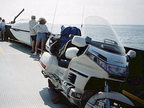
I took the NCDOT Ferry Division free ferry to Ocracoke Island and then the not-so-free one to Cedar Island. Someone advised me to reserve a place on the ferry to Cedar Island. Because of close timing due to the schedules, I made a reservation on the ferry that would leave Ocracoke Island about two hours after I arrived at the terminal. Fortunately, I pulled up just in time to catch the earlier ferry, which wasn't full. From there, I rode US-70 southwest to Morehead City, then northwest through Havelock, New Bern, and Kinston to Goldsboro. I was able to phone Gordon from there around 10:00 PM, so I took US-13 on to Fayetteville, and arrived at the motel around 11:30.
Tuesday, July 18, 2000
Gordon went to his meeting this morning, and I slept in (what a surprise!). His meeting went long, and we met up at the Fort Bragg Post Exchange for a late lunch. That put us on the road later than planned. We took Highway 87 and US-421 to Siler City, then US-64 to I-40 near Mocksville.
Just as we were exiting one highway onto another today, some goofball in a pickup truck just to Gordon's left suddenly decided he had to take the same exit at the same time. Without a glance, he swerved across the road to the exit and almost into Gordon, who sillfully managed to make room for the interloper. The unconscious pickup truck driver never knew how close he came to causing a crash.
Though we had to go our separate ways on Saturday, we ended up finishing the trip together. We finally reached Asheville and home around 7:30 PM. The Goldwings have landed.
| Trip Statistics | ||
|---|---|---|
| Wil | Gordon | |
| Total Trip Mileage: | 10,078 | a little less |
| Countries: | 2 | 2 |
| States: | 21 | 21 |
| National Parks, Memorials, etc.: | 13 | 11 |
| State Parks: | 6 | 5 |
| Ferries: | 4 | 2 |
| Camping Nights: | 22 | 21 |
| Motel Nights: | 11 | 10 |
| Close Calls: | 1 | 1 |
| Goldwing Breakdowns: | None | |
| Camping Gear Problems: | None | |
| Pictures: | Lots! | |
| Was it worth it? | Oh, yeah! | |